GPS Diagnostic is an iPhone & iPad application. It is the reference standard for GPS Test & Measurement on the App Store, and is an essential tool to use alongside your existing navigation apps.

GPS Diagnostic is one of the highest rated apps in the App Store with consistent 5 star ratings.
KEY FEATURES:
- Professional GPS test and measurement utility for your iPhone and iPad.
- Supplements the operation of any navigation app, or any app that requires a location.
- If location cannot be determined then it diagnoses why, and assists you in changing conditions to get a reliable location.
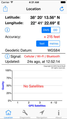
- Satellite Bar Chart. A unique and innovative design that displays all essential satellite information using a chart with only 4 bars (Copyright © 2015 David Ryall, All rights reserved).
- Uses the internal GPS of the iPhone or iPad.
- Location and altitude ( best accuracy and reliability on the app store )
- Essential tool for any power user.
(e.g. navigators, yachtsmen, pilots, app developers)
- Share and copy location in Lodestone Location Format for improved location accuracy.
(e.g. 37.334560 N, 122.035833 W, +/-5 metres, WGS84, Decimal Degrees).
- Powered by Lodestone Wireless algorithms.
- Professional GPS test and measurement utility for your iPhone and iPad.
- Supplements the operation of any navigation app, or any app that requires a location.
- If location cannot be determined then it diagnoses why, and assists you in changing conditions to get a reliable location.
- Satellite Bar Chart. A unique and innovative design that displays all essential satellite information using a chart with only 4 bars (Copyright © 2015 David Ryall, All rights reserved).
- Uses the internal GPS of the iPhone or iPad.
- Location and altitude ( best accuracy and reliability on the app store )
- Essential tool for any power user.
(e.g. navigators, yachtsmen, pilots, app developers)
- Share and copy location in Lodestone Location Format for improved location accuracy.
(e.g. 37.334560 N, 122.035833 W, +/-5 metres, WGS84, Decimal Degrees).
- Powered by Lodestone Wireless algorithms.
|
|
|
|
|
|
|
|
Screen Designs, Features, Intellectual Property, Implementation Concepts = Copyright(c) 2014, 2015, 2016 David Ryall
Key design features:
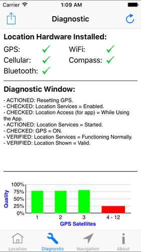
i) DIAGNOSTIC WINDOW
A scolling text window allows detailed information about the state of the location services to be displayed to the user. The information may include debug information.
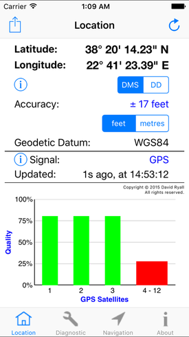
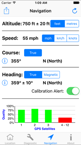
ii) SATELLITE BAR CHART (Lodestone Chart)
A unique and innovative design that displays all essential satellite information using a chart with only 4 bars (Copyright © 2015 David Ryall, All rights reserved, Registered Copyright).
Satellites 1,2 and 3 are shown independently, and the remaining satellites are all bundled into a final bar. This is sufficient and optimum information to measure the performance of your geolocation satellite receiver which includes GPS and GLONASS within the iPhones and iPads but the idea is applicable for other systems.
It allows the user to debug location and performance issues related to the iPhone or iPad. For example, if the user sees a small number of satellites or the signal quality is weak then the user knows to move the device to a location with improved satellite visibility.
The signal quality updates in real time. As you change location you will observe changes in the signal quality.
The satellite bar chart is displayed on each screen of the application so the user knows the current status of the received location. This is a key design feature.
The satellite bars are either red or green. Simplicity of color coding was a key design feature here. When the bars are all green the user has excellent signal reception. When one or more of the bars are red then the user should consider repositioning the iPhone or iPad for improved satellite signal strength.
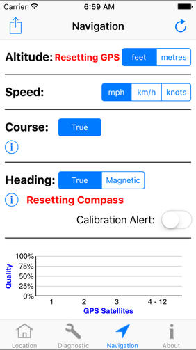
iii) UPDATE PARAMETER
To demonstrate that the app is active and constantly monitoring the location, there is an "Update" parameter. Either the time (on the left side) is updating every second or the time (on the right) is updating every second. So one of the two times is always moving to demonstrate that the app is active.
iv) GEODETIC DATUM
Knowing the Geodetic Datum used to make the location measurement is important when working with charts and maps. The map/chart should use the same Geodetic Datum as the location measurement. Differences of 1km are possible between mismatching Geodetic Datums. The Geodetic Datum is usually printed on the map/chart.
v) LOCATION HARDWARE INSTALLED
Hardware installed and used for location and heading services is shown.
vi) RESETTING GPS & COMPASS
On very rare occasions or when satellite signal strength is very weak then a location may be difficult to obtain or measurement accuracy may be very poor. In this case, a reset can help find a location or improve measurement accuracy. It may also have the effect of helping other navigation apps that are running in the background and struggling to find a location.
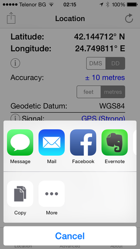
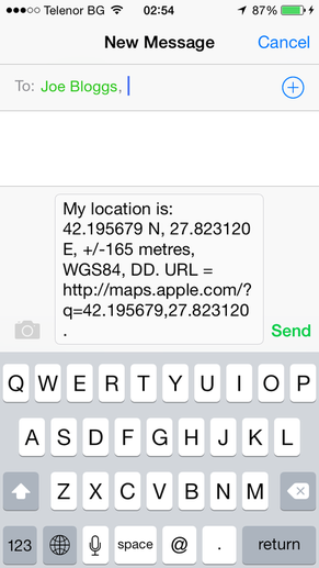
vii) LODESTONE LOCATION FORMAT
Location is shared or copied in a format (aka Protocol) with enhanced information about the original measurement. This is useful information for a navigator.
E.g. 1: Lodestone Location Format = 45.123456 N 23.123456 E, +/-5m, WGS84, Decimal Degrees.
or
E.g. 2: Lodestone Location Format = 45.123456 N 23.123456 E, +/-5m, WGS84, DD.
The key points are:
a) Sending or copying the measured location accuracy is useful information, because Geographic Coordinates can be measured inaccurately. For example +/-65m with WiFi, and +/- 1km with Cellular are typical.
b) Knowing the Geodetic Datum used to make the location measurement is important when working with charts and maps. Differences of 1km are possible between mismatching Geodetic Datums. The map/chart should use the same Geodetic Datum as the location measurement. The Geodetic Datum is usually printed on the map/chart.
c) The measured units are important. Decimal Degrees are used and clearly stated.
d) Text messages are sent in ASCII, therefore the message fits in one Text Message (160 characters). Using Non-Unicode characters improves transmission costs and transmission reliability (because only one text message is required).
e) A URL is added for convenient map access when internet is available.
f) An example of a Geographic Coordinate in Lodestone Location Format with URL is:
Text Message = My location is: 45.123456 N 23.123456 E, +/-5m, WGS84, Decimal Degrees. URL = http://maps.apple.com/?q=45.123456,23.123456.
Key design features:
i) DIAGNOSTIC WINDOW
A scolling text window allows detailed information about the state of the location services to be displayed to the user. The information may include debug information.
ii) SATELLITE BAR CHART (Lodestone Chart)
A unique and innovative design that displays all essential satellite information using a chart with only 4 bars (Copyright © 2015 David Ryall, All rights reserved, Registered Copyright).
Satellites 1,2 and 3 are shown independently, and the remaining satellites are all bundled into a final bar. This is sufficient and optimum information to measure the performance of your geolocation satellite receiver which includes GPS and GLONASS within the iPhones and iPads but the idea is applicable for other systems.
It allows the user to debug location and performance issues related to the iPhone or iPad. For example, if the user sees a small number of satellites or the signal quality is weak then the user knows to move the device to a location with improved satellite visibility.
The signal quality updates in real time. As you change location you will observe changes in the signal quality.
The satellite bar chart is displayed on each screen of the application so the user knows the current status of the received location. This is a key design feature.
The satellite bars are either red or green. Simplicity of color coding was a key design feature here. When the bars are all green the user has excellent signal reception. When one or more of the bars are red then the user should consider repositioning the iPhone or iPad for improved satellite signal strength.
iii) UPDATE PARAMETER
To demonstrate that the app is active and constantly monitoring the location, there is an "Update" parameter. Either the time (on the left side) is updating every second or the time (on the right) is updating every second. So one of the two times is always moving to demonstrate that the app is active.
iv) GEODETIC DATUM
Knowing the Geodetic Datum used to make the location measurement is important when working with charts and maps. The map/chart should use the same Geodetic Datum as the location measurement. Differences of 1km are possible between mismatching Geodetic Datums. The Geodetic Datum is usually printed on the map/chart.
v) LOCATION HARDWARE INSTALLED
Hardware installed and used for location and heading services is shown.
vi) RESETTING GPS & COMPASS
On very rare occasions or when satellite signal strength is very weak then a location may be difficult to obtain or measurement accuracy may be very poor. In this case, a reset can help find a location or improve measurement accuracy. It may also have the effect of helping other navigation apps that are running in the background and struggling to find a location.
vii) LODESTONE LOCATION FORMAT
Location is shared or copied in a format (aka Protocol) with enhanced information about the original measurement. This is useful information for a navigator.
E.g. 1: Lodestone Location Format = 45.123456 N 23.123456 E, +/-5m, WGS84, Decimal Degrees.
or
E.g. 2: Lodestone Location Format = 45.123456 N 23.123456 E, +/-5m, WGS84, DD.
The key points are:
a) Sending or copying the measured location accuracy is useful information, because Geographic Coordinates can be measured inaccurately. For example +/-65m with WiFi, and +/- 1km with Cellular are typical.
b) Knowing the Geodetic Datum used to make the location measurement is important when working with charts and maps. Differences of 1km are possible between mismatching Geodetic Datums. The map/chart should use the same Geodetic Datum as the location measurement. The Geodetic Datum is usually printed on the map/chart.
c) The measured units are important. Decimal Degrees are used and clearly stated.
d) Text messages are sent in ASCII, therefore the message fits in one Text Message (160 characters). Using Non-Unicode characters improves transmission costs and transmission reliability (because only one text message is required).
e) A URL is added for convenient map access when internet is available.
f) An example of a Geographic Coordinate in Lodestone Location Format with URL is:
Text Message = My location is: 45.123456 N 23.123456 E, +/-5m, WGS84, Decimal Degrees. URL = http://maps.apple.com/?q=45.123456,23.123456.